https://en.wikipedia.org/wiki/AUKUS
AUKUS - Wikipedia
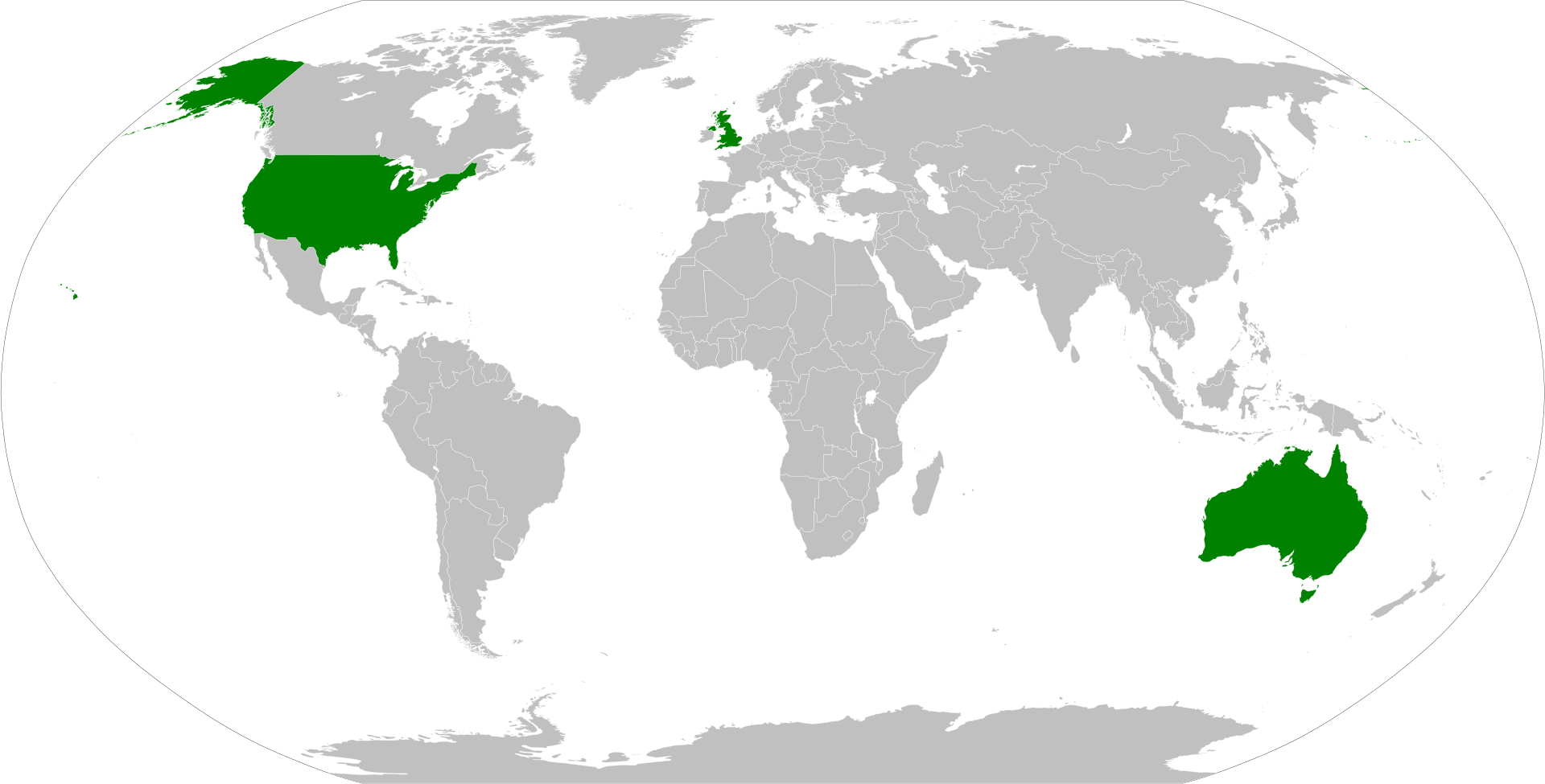
From Wikipedia, the free encyclopedia Jump to navigation Jump to search Australia–UK–US security pact AUKUS (, AW-kəs), also styled as Aukus, is a trilateral security pact between Australia, the United Kingdom and the United States, announced on 15 Se
en.wikipedia.org
오스트레일리아, 영국, 미국 3국이 맺은 군사안보동맹 AUKUS
중국의 인도-태평양 지역에서의 세력 팽창에 대비하여, 미국이 영국, 오스트레일리아와 앵글로색슨 동맹 강화
특히 최근 오스트레일리아의 핵잠수함에 미국과 영국이 지원을 하는 것으로 표출됨
그런데 지도를 보면, 위와 같이 3국이 이곳저곳에 흩어져 있어서, 도대체 어떤 동맹으로 뭘 하겠다는건지 잘 안드러남
서구에서 주로 쓰는 대서양 중심 지도에서는, 지금과 같이 태평양에서의 이슈를 시각적으로 드러내는 데 한계가 있음
하지만 아래 사이트에서 AUKUS 동맹 구도를 잘 드러내는 지도를 발견함
https://twitter.com/RhodesCartogra1/status/1454464696489332741/photo/1
Rhodes Cartography on Twitter
“Another attempt to visualize #AUKUS at both the strategic and operational levels. Still a developing sketch. @JerryHendrixII @CSBA. Featuring two typefaces by @sarahbellmaps. Posted here: https://t.co/vb6IoMf45f”
twitter.com
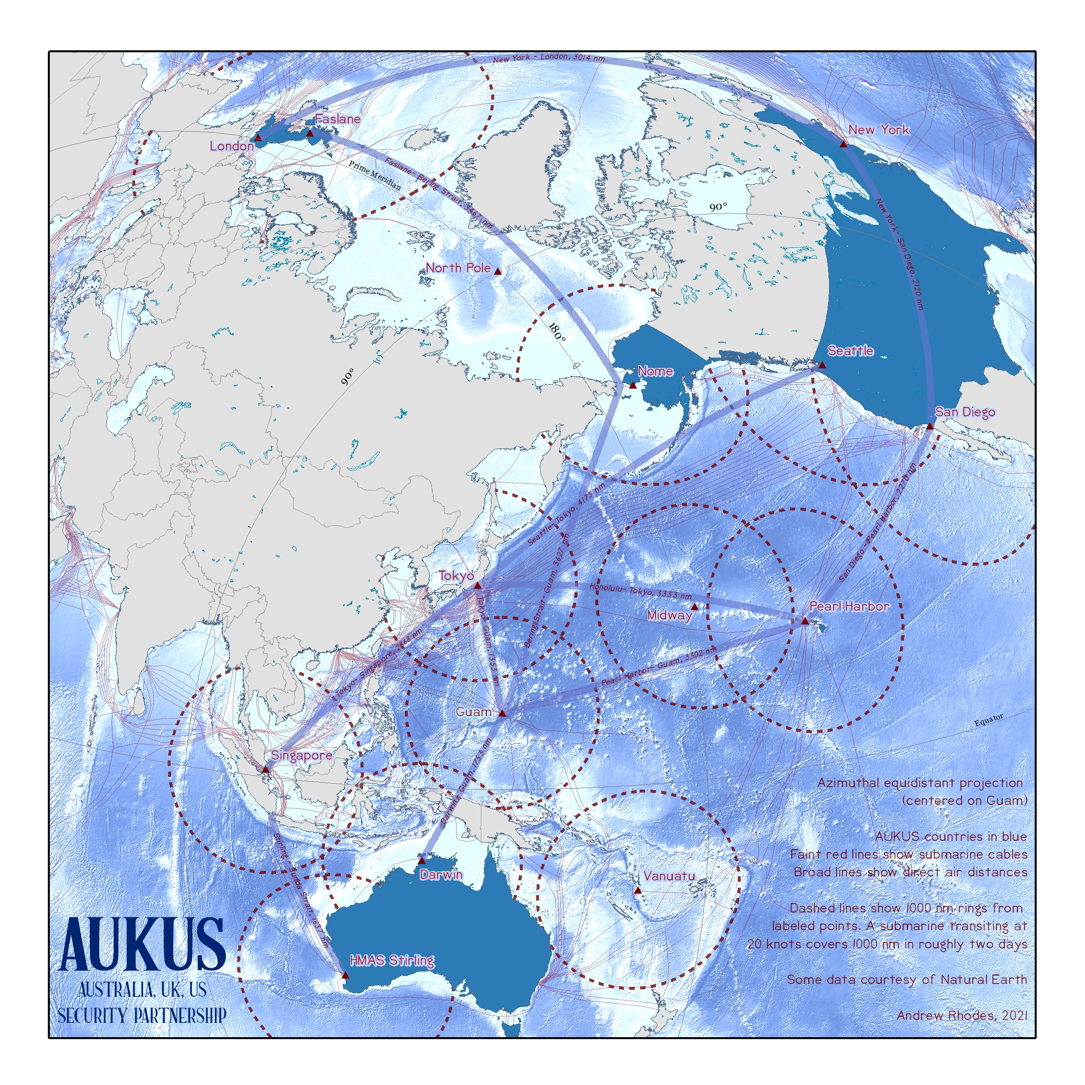
https://thinkinginspace.net/latest-maps/f/another-aukus-map
괌을 중심으로 정거방위도법(azimuthal equidistant projection)으로 그린 지도라고 함
우선 대서양 중심이 아니라 태평양 중심이어서, 미국과 인도-태평양 지역이 생각보다 더 가깝다는 점을 보여줌
그리고 유라시아 대륙과 북아메리카 대륙이 생각보다 더 가깝다는 점도 보여줌
이러한 투영법은 지정학적 연계 및 대립 구도를 더욱 확연하게 보여주는 효과가 있음
'인문지리 > 지도학과 GIS' 카테고리의 다른 글
| 알 이드리시의 세계지도에 대한 탐구 (0) | 2022.01.13 |
|---|---|
| 우주물리학자가 고안한 '양면 세계 지도' (0) | 2021.11.19 |
| 헝가리 국빈방문에서 받은 고지도 고찰 (0) | 2021.11.06 |
| 메르카토르의 세계 지도와 페터스의 세계 지도 + 맥아더의 세계 지도 (0) | 2021.11.02 |
| 슬라브 국가(Slovanský zeměvid) 지도 (0) | 2021.10.26 |


